Unit 4 – Topic 4.2: How Historical Processes Shape Political Boundaries
Use this page to learn about key historical processes in political geography. You will use this information to complete your independent assignment on sovereignty, nation-states, colonialism, imperialism, independence movements, and devolution.
Key Vocabulary
- State: A political unit with a defined boundary, a permanent population, a government, and sovereignty over its internal and foreign affairs (often called a "country").
- Nation: A group of people with a shared culture, history, and sense of identity, often tied to a specific homeland.
- Nation-state: A state whose borders closely match the territory of a particular nation or cultural group (for example, Japan or Iceland).
- Stateless nation: A cultural group that does not have its own independent state and may be spread across several countries (for example, the Kurds or Palestinians).
- Sovereignty: The full right and power of a state to govern itself without interference from other states.
- Self-determination: The idea that nations have the right to choose their own government and political future.
- Colonialism: When a country establishes settlements in a foreign territory and directly controls its people and resources (for example, European powers in Africa).
- Imperialism: A broader policy of extending a country’s power and influence over other regions, often through political or economic control, sometimes without large-scale settlement.
- Independence Movement: Efforts by a group or colony to gain political independence and form their own state (for example, India gaining independence from Britain).
- Devolution: The process in which a central government transfers power to regional or local governments (for example, Scotland gaining its own parliament within the UK).
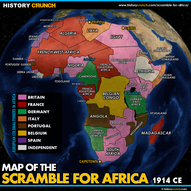
Case A: The Berlin Conference & the Partition of Africa
In 1884–1885, European leaders met at the Berlin Conference to decide how to divide the continent of Africa among European powers. No African leaders were invited. Europeans drew borders mostly as straight lines on a map, based on their own interests and negotiations.
These new borders often combined rival ethnic groups into the same state or split cultural groups across multiple states. After independence in the 1900s, most African countries kept these colonial borders, which still shape politics, conflict, and identity today.
- Which historical process does this case represent?
- How did the Berlin Conference shape today’s political boundaries in Africa?
- What is one modern consequence of these artificial borders?
Map suggestion: Search for "Scramble for Africa map" or "Colonial Africa 1914" to see how Europeans divided the continent.
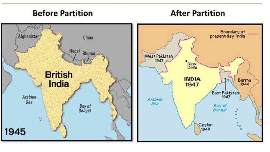
Case B: Partition of India (1947)
For almost 200 years, Britain controlled the Indian subcontinent. After World War II, Indian leaders pushed for independence. In 1947, Britain agreed to leave but divided the territory into two main states: India and Pakistan. The border was drawn mostly along religious lines—areas with Hindu majorities became India, and areas with Muslim majorities became Pakistan.
This division caused one of the largest migrations in history. Millions of Hindus and Muslims moved across the new borders, and violence broke out between communities. Today, the borders between India and Pakistan remain heavily militarized, and the region of Kashmir is still disputed.
- Which historical process does this case best represent?
- How did religion influence the drawing of the boundaries?
- How does this boundary continue to affect South Asia today?
Map suggestion: Search for "Map of British India before and after 1947" to compare how borders changed.
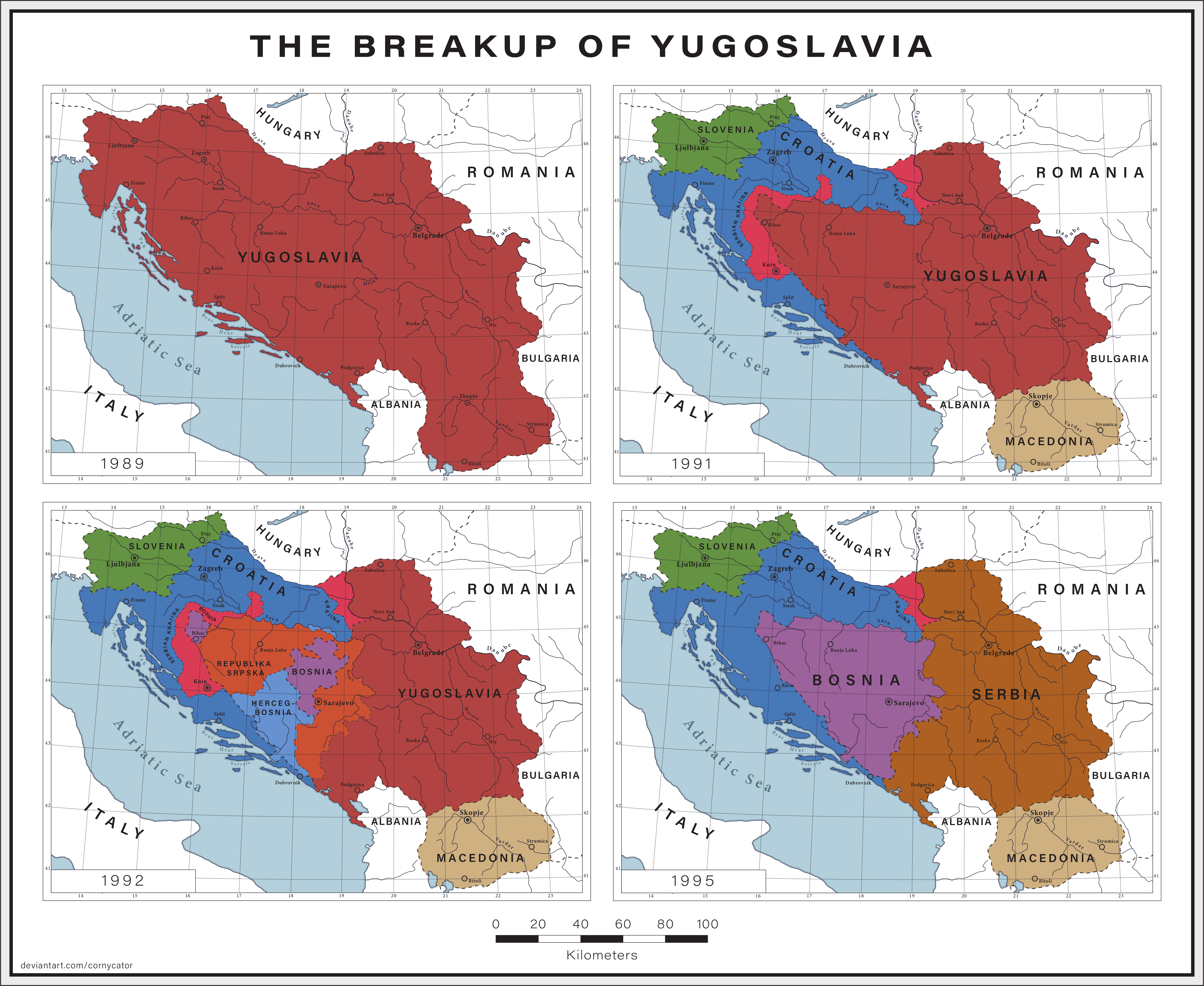
Case C: The Breakup of Yugoslavia
Yugoslavia was a country in Southeast Europe made up of several different ethnic groups, including Serbs, Croats, Bosniaks, Slovenes, Macedonians, and others. After the fall of communism in Europe, tensions between these groups increased. In the 1990s, several republics within Yugoslavia declared independence, including Slovenia, Croatia, Bosnia & Herzegovina, and later others.
The breakup led to violent conflicts, including ethnic cleansing and civil wars. Over time, new internationally recognized states formed, and the political map of the Balkans changed dramatically.
- Which historical process is illustrated in this case?
- How did ethnicity and national identity influence the creation of new states?
- How did the breakup of Yugoslavia change the political map of Europe?
Map suggestion: Search for "Yugoslavia map before and after 1990" to see how the region was divided into new countries.
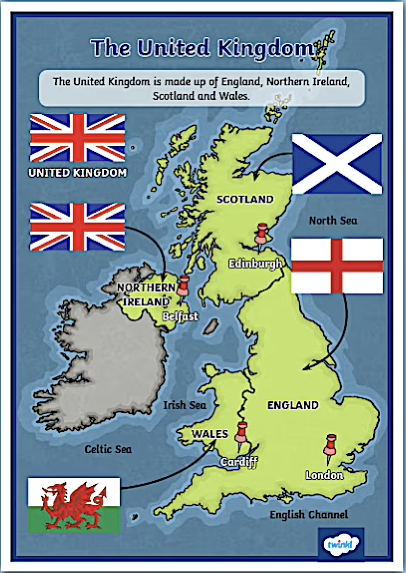
Case D: Scotland and the United Kingdom
Scotland is part of the United Kingdom (UK) but has its own distinct history, legal system, and cultural identity. Many people in Scotland identify as Scottish rather than British. In 1999, the UK government granted Scotland its own parliament with some control over local issues like education and health. This is an example of devolution, where power is transferred from the central government to a regional one.
In 2014, Scotland held a referendum on whether it should become an independent state. A majority voted to remain in the UK, but debates about independence continue, especially after the UK voted to leave the European Union (Brexit) while many Scots voted to remain.
- Which historical process does this case represent?
- Why do some people in Scotland support independence?
- How does this example show the idea of self-determination?
Map suggestion: Search for "Map of the United Kingdom and Scotland" to see how Scotland fits within the UK.
Next Steps: Using This Page for Your Assignment
Use the information and suggested maps from this page to help you complete your Unit 4.2 Independent Assignment in your digital platform.
- Use the case studies above to identify historical processes.
- Pay attention to how borders were drawn and how that affected people.
- Use the images and suggested map searches as evidence in your answers.
Keep this page open in a tab while you work on your assignment so you can refer back to the examples and visuals.